KWB-FB – Het Government Rest House in No. 63 Village
Police Post 63 of Government Rest House.
In het onderstaande wordt geciteerd uit de correspondentie tussen het hoofd van de Britse grenscommissie( J.F. Phipps) en het hoofd van de Nederlandse grenscommissie( C.C. Kayser), waaruit de konklusie getrokken kan worden dat de verlaten Police Post 63 en het Government Rest House in No. 63 Village( Benab) niet dezelfde plaats zijn.
Telegram from the Government of British Guiana to the Secretary of State for the Colonies.
Dated the 9th April, 1935 (Received 6.10 p.m. 9th April, 1935.)
No. 86. 9th April. Your telegram No. 73* Surinam Boundary. Police station maintained until few years ago at No. 63 in approximately latitude 5°58’53″N and longitude 57°08’54″W would appear to be suitable site for erection of landmark(s) and starting point for boundary, as the line prolonged seawards from that point on the true bearing N.28°E. would apparently pass across sandbank known as Thursday Cay on which if so desired beacons could be erected. If time allows I suggest that the Chief British Commissioner should inspect the proposed site in order to ascertain its suitability. This would take about a fortnight.
Surinam Boupdary—(C.21838/35). 12
British Guiana Brazil Boundary Commission, King Frederic Falls, April 17th 1936
[…]
I have now received a copy of your chart of the Courantyne mouth and the coordinates given in the Draft Treaty seem to be those of a sandbank which is submerged at high tide. From the correspondence about the matter I understand that the coordinates are intended to refer to an old Police Post marked on the chart by ‘Police Post 63’. This is at one of the few dry spots along the coast and is now a small private hotel, where officials sometimes send their families for a holiday, as there is a small sand beach there. The coordinates of No. 63 do not agree exactly with those of the Draft Treaty, but as they are different on every map we possess this is probably not so important as having some firm ground on which to build the pillar and to fix the position of that point astronomically at a convenient time. When we go down I will get all the information I can get about the place and write to you again.
( signed J.F. Phipps)
British Guiana Brazil Boundary Commission, 71 Murray Street, Georgetown, 22nd. May, 1936
[…]
Regarding the point at the mouth of the Courantyne there is a small Gouvernment Rest House at 63, which has 2 bedrooms and also a slightly larger private boarding house next door. The Gouvernment Rest House does not provide food but we can no doubt arrange about that. It is occupied at present, but I am arranging for it to be allotted to us in July, and I am also seeing what accommodation we can obtain in the boarding house. In any case I think we should be able to fix up things satisfactorily and will write to you again about this.
( signed J.F. Phipps)
.
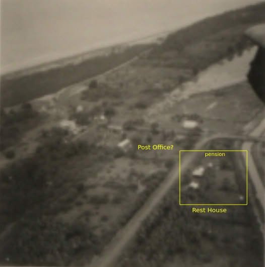
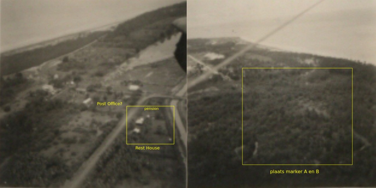
No. 63 Village, Rest House en Astro Pillar vanuit NW.
De koordinaten van marker A zijn afgeleidt van astronomische metingen in No. 63 Village( Benab) nabij het Government Rest House. Zowel de Britse en de Nederlandse Grenscommissie hebben daar astronomische metingen verricht( 5°59’0.09″N, 57°08’55.12″W). Van de verdwenen marker A zijn twee verschillende waarden gepubliceerd, welke verkregen zijn door het meten van een polygoon vanuit Benab. Tijdens de bepaling van de maritieme grens door het PCA in 2006 kon de technical expert van het tribunaal de plaats van het Britse astronomisch station in Benab niet reconstrueren( zie technical report site visit). De onderstaande foto laat zonder twijfel de plaats van het Government Rest House in Benab zien, waar blijkbaar de Britse astronomische metingen zijn gedaan. In de foto is het gebouw naast het Gouvernment Rest House een pension. In ieder geval kan gesteld worden dat de analyse van de technical expert van het PCA tribunaal v.w.b. de plaats van het Britse astronomisch station in No. 63 Village( Benab) niet correct is.
.
BIJLAGE I bij HY-1001
Gegevens grens Suriname – Brits Guyana
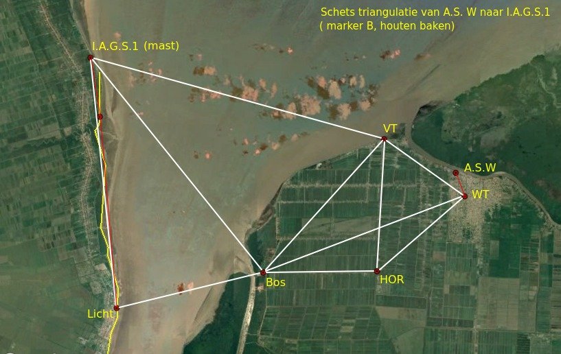
In 1936 werd door een Brits-Nederlandse grenscommissie de positie bepaald van het N-lijkste cementen baak van een stel “concrete markers” (“A buried”, zie schets) aan de W-zijde van Corantijn mond met als uitkomst:
5°59’53”,8 N / 57°8’51”,5 W (zie archief Hydrografie No. 36515/2/28-5 maart 1959). 3 m beN “A buried” in richting 10° werd “Pillar A” opgericht. In richting 190° 220m van “A buried” werd “B buried” geplaatst en 3 m in dezelfde richting “Pillar B”. Voorts werd een “Wooden Beacon” opgericht op ± 30 m in richting 190° van “B buried”
Het houten baken is een driekantige piramide, 10 m hoog, op een basis waarvan de zijden 10 m lang zijn. Het baken is wit geschilderd en gelegen op een stuk onbebouwd land ± 1400 m Noord van “Village 63” (Benab) (zie notulen 3e zitting commissie, belast met het bepalen van de grens tussen Suriname en Brits-Guyana in archief Chef Hydrografie).
De positie van dit baken is volgens de officiële stukken in archief Chef Hydrografie: 5°59’45”,7 N/ 57°08’52”,7 W.
Dit baken is vanuit zee zichtbaar. Volgens B.a.Z. 250/3179-1938 geeft een lijn vanuit dit baken getrokken in richting N 010° E de grens aan tussen de Nederlandse en Britse territoriale wateren in de Corantijn monding. Voorts geeft dit B.a.Z. aan, dat het houten baak 6,05 zm 356,5° vanaf de schoorsteen van Springlands is gelegen. Daar deze schoorsteen verdwenen is, werd van dit gegeven geen gebruik meer gemaakt. Het houten baken komt niet meer voor op de Ned. zeekaart 2228, wel de “Traliemast” waarvan de coördinaten, gebaseerd op de luchtkaartering KLM bedragen;
5°59’41”,67 N en 57°08’49”,76 W
5°59’45”,70 N en 57°08’52”,70 W
4″,03 en 2″,94( 120m en 88m)
Waarschijnlijk is dus, dat het houten baken indertijd is vervangen door een traliemast. Havenwezen Paramaribo heeft telegrafisch deze veronderstelling bevestigd. Bovenstaande verschillen van ± 120 m in breedte en ± 88 m in lengte geven bovendien een indruk van de aansluiting Ned zeekaarten aan Brits-Guyana, die, zoals blijkt, geringe verschillen oplevert. Uit de correspondentie blijkt (zie No. 2658/209 – 8 maart 1962 archief Hydrografie), dat tijdens de metingen van de “Inter-American Geodetic Survey” in 1960 een poging werd gedaan om “Buried Mark A” en “Pillar A” terug te vinden. Bevonden werd, dat “Buried Mark A” was verplaatst door de zee en dat “Pillar A” verdwenen was.
Voorgesteld werd om een nieuw merkteken te plaatsen in richting 190° van “Mark B” 100m landwaarts en dit te noemen “Mark C”. Bij schrijven No. 1846/209Wk – 1962 werd door de Minister van Defensie (Marine) aan de Minister van Buitenlandse Zaken medegedeeld, dat zijnerzijds geen bezwaren bestonden betreffende de plaatsing van “Mark C”, waarbij verzocht werd om bij deze plaatsing richtingen en afstanden te bepalen van “Mark B” tot de traliemast, c.q. houten baken en het A.S. punt Kayser Phipps 1936, nabij het, “Government Rest House” te Benab, bestaande uit een “small concrete mark”, gelegen 8,5m van de NE-hoek en 14,4m van de NW-hoek van genoemd “Rest House”, en waarvan de coördinaten bedragen: 5°59’0″,09 N en 57°08’55”,12 W. Tot op heden werd op dit verzoek niet gereageerd.
Site Visit Report Technical Expert PCA Tribunaal( 24 July 2007).
In het Site Visit Report van 24 July 2007 schrijft de technical expert van het PCA tribunaal in par. 17, 36 en 38 het volgende m.b.t. de plaats van het Britse astronomisch station in No. 63 Village.
17.Sixty Three Rest House:
A search was made for the British Astronomical Point described in Major Phipps and Admiral Kayser’s 1936 report but it was not found. The probable location is now a derelict well or in-ground cistern or possibly a septic tank. Also, the probable location does not now meet the requirements of an astronomical observing point in the fact that the building obstructs much of the view of the stars along the meridian. Therefore a GPS point was observed south of the building where the sky was visible. etc.
36.Assuming that the GPS receiver was working correctly while at the point near Rest House 63, it appears that the wrong building was visited. Given the mean datum shifts in paragraph 34, the building that should have been visited was some 900 feet (275 metres) farther east and 350 feet (100 metres) farther south. Thus the building would have been on the south side of the road, and not the north side. The astronomical station would have been on the road side of the building and not behind the building. Therefore, I consider it wrong to conclude that the astronomical station is lost, because the search apparently was being made in the wrong location.
38.The British Astronomical station near Rest House 63, referred to in Major Phipps and Admiral Kayser’s 1936 report, was not found because the wrong area was searched.
Wat een groot schandaal.
In de beschrijving wordt de N 010° E richting vanuit marker A landinwaarts met marker B vastgelegd( richting AB met azimut van 190°). Is het dus toeval dat de richting van het Britse astronomisch station naar marker A samenvalt met de N 010° E richting? Blijkbaar wordt de N 010° E richting dus bepaald door het azimut van het Britse astronomische station( welke men niet terug kon vinden ![]() ) naar marker A. Wat hebben de z.g. experts de zaak toch belazerd.
) naar marker A. Wat hebben de z.g. experts de zaak toch belazerd.
Indien wordt aangenomen dat de fout in marker A even groot is als die in het Britse astronomisch station, dan suggereert het azimut van het Britse astronomisch station naar marker A( 3°51’37.0″) dat men marker B heeft verplaatst.
Het Government Rest House in No. 63 Village( Benab) en de plaats van marker A en B.
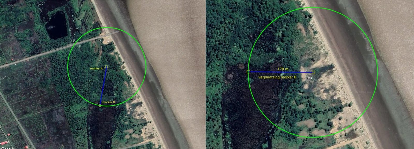
Is marker B in het terrein verplaatst?
De plaats van het Britse astronomisch station in No. 63 Village( Government Rest House) suggereert dat marker B over een afstand van 179 m in oostelijke richting naar de huidige positie in het terrein is verplaatst. Het azimut van het Britse astronomische station naar marker B( huidige positie) definieert dan de N 10° E lijn. Is marker B niet verplaatst, dan moet aangenomen worden dat de N 10° E lijn gedefinieerd wordt door de richting van het Britse astronomisch station naar marker A( niet correct, want het azimut is 3°51’37.0″).
.
.
.