Grids & Datums – Guyana
https://www.asprs.org/a/publications/pers/2021journals/04-21_April_Flipping_PUBLIC.pdf
https://www.asprs.org/wp-content/uploads/2012/05/03-2006-guiana.pdf
by Clifford J. Mugnier, CP, CMS, FASPRS
By Clifford J. Mugnier, CP, CMS, FASPRS
The Grids & Datums column has completed an exploration of every country on the Earth. For those who did not get to enjoy this world tour the first time, PE&RS is reprinting prior articles from the column. This month’s article on the Co-operative Republic of Guyana was originally printed in 2003 but contains updates to their coordinate system since then.
Historical Overview
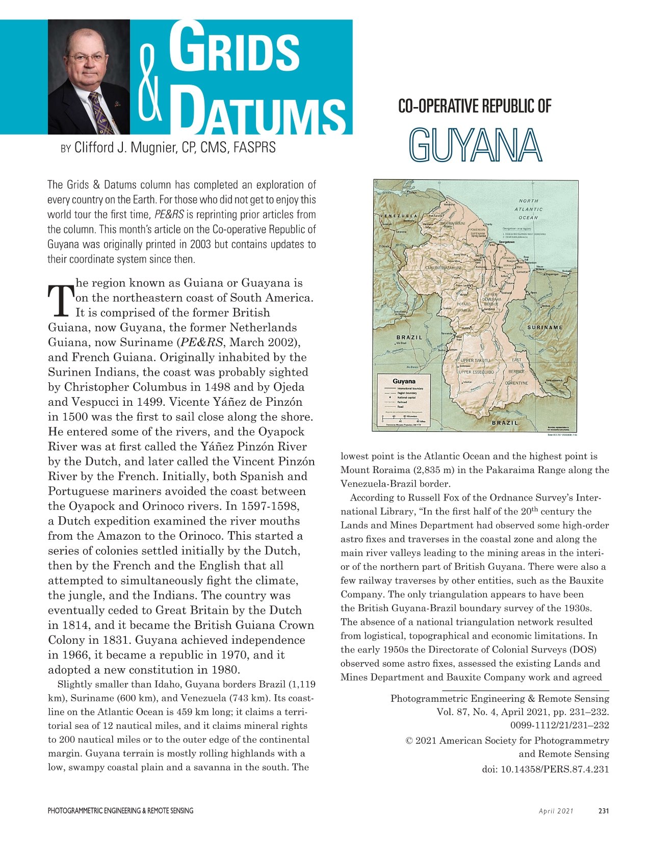
The region known as Guiana or Guayana is on the northeastern coast of South America. It is comprised of:
- The former British Guiana, now Guyana
- The former Netherlands Guiana, now Suriname (PE&RS, March 2002)
- French Guiana
Originally inhabited by the Surinen Indians, the coast was probably sighted by Christopher Columbus in 1498 and by Ojeda and Vespucci in 1499. Vicente Yáñez de Pinzón in 1500 was the first to sail close along the shore. He entered some of the rivers, and the Oyapock River was at first called the Yáñez Pinzón River by the Dutch and later called the Vincent Pinzón River by the French.
Initially, both Spanish and Portuguese mariners avoided the coast between the Oyapock and Orinoco rivers. In 1597–1598, a Dutch expedition examined the river mouths from the Amazon to the Orinoco. This started a series of colonies settled initially by the Dutch, then by the French and the English, all of whom attempted to simultaneously fight the climate, the jungle, and the Indians.
The country was eventually ceded to Great Britain by the Dutch in 1814, became the British Guiana Crown Colony in 1831, achieved independence in 1966, became a republic in 1970, and adopted a new constitution in 1980.
Geography
Slightly smaller than Idaho, Guyana borders:
- Brazil (1,119 km)
- Suriname (600 km)
- Venezuela (743 km)
Its coastline on the Atlantic Ocean is 459 km long. Guyana claims:
- A territorial sea of 12 nautical miles
- Mineral rights to 200 nautical miles or to the outer edge of the continental margin
The terrain is mostly rolling highlands with a low, swampy coastal plain and a savanna in the south.
- Lowest point: Atlantic Ocean
- Highest point: Mount Roraima (2,835 m), Pakaraima Range, along the Venezuela–Brazil border
Survey and Mapping History
According to Russell Fox of the Ordnance Survey’s International Library:
“In the first half of the 20th century the Lands and Mines Department had observed some high-order astro fixes and traverses in the coastal zone and along the main river valleys leading to the mining areas in the interior of the northern part of British Guyana.
There were also a few railway traverses by other entities, such as the Bauxite Company. The only triangulation appears to have been the British Guyana–Brazil boundary survey of the 1930s.
The absence of a national triangulation network resulted from logistical, topographical and economic limitations.”
In the early 1950s, the Directorate of Colonial Surveys (DOS) observed some astro fixes, assessed the existing Lands and Mines Department and Bauxite Company work, and agreed on an adjustment strategy to produce a unified set of coordinates from disparate but high-quality traverses and fixes.
The method accepted certain fixes and traverses and adjusted weaker ones to fit—there was not a single datum station.
System adopted:
- British Guyana Grid (Transverse Mercator Projection)
- Reference ellipsoid: International (a = 6,378,388; 1/f = 297)
- Latitude of Origin (φ₀): Equator
- Central Meridian (λ₀): 59° W of Greenwich
- False Easting: 900,000 feet
- False Northing: Nil
- Central Scale Factor (m₀): 0.99975
In the late 1960s, the U.S. Inter-American Geodetic Survey observed a Hiran trilateration between Venezuela and Brazil. DOS used that as the basis for a new national network for Guyana, and in 1971 computed an adjustment based on the 1970 Aerodist values of Hiran stations Atkinson and Rose. DOS called this the Provisional South American Datum of 1956 (PSAD56).
The International ellipsoid was retained, but the UTM Grid replaced the British Guyana Grid.
Geodetic Details
According to John W. Hager (formerly of NIMA):
- DOS astro fix at Georgetown Lighthouse was published as the mean of determinations observed in 1926 and 1951:
- φ₀ = 6° 49′ 31.12″ N
- λ₀ = 58° 09′ 52.76″ W (Greenwich)
- International ellipsoid (as in Guyana Trig List, 3rd edition)
Hager noted that five stations were established in Guyana as part of the Hiran net from the Caribbean to Brazil. Only Station Eagle was held fixed in the Terra Surveys Limited network (Canada, ~1968).
Station Eagle on PSAD56:
- φ₀ = 5° 13′ 23.6660″ N
- λ₀ = 59° 06′ 10.0549″ W
PSAD56 Origin:
- La Canoa, Anzoátegui Province, Venezuela
- φ₀ = 08° 34′ 17.170″ N
- λ₀ = 63° 51′ 34.880″ W
- Azimuth to Pozo Hondo α₀ = 40° 22′ 45.96″ (PE&RS, December 2000)
Distances:
- La Canoa → Georgetown Lighthouse: ~657 km
- Zanderij Datum Origin (Suriname) → Georgetown Lighthouse: ~361 km
Boundaries and Political Context
Of all Guyana’s borders, only the Brazil–Guyana boundary is currently stable and uncontested.
Historically, the region’s colonial squabbles involved the British, Dutch, French, Venezuelans, and Portuguese.
More recently, there have even been maritime disputes (so-called “gunboat diplomacy”) between Guyana and Suriname over offshore oil and gas resources.
Some diplomatic papers on the matter are publicly available online.
Coordinate Transformation
The latest transformation parameters from NIMA for shifting PSAD56 → WGS84 in Guyana are:
| Parameter | Value | Uncertainty |
|---|---|---|
| ΔX | –298 m | ±6 m |
| ΔY | +159 m | ±14 m |
| ΔZ | –369 m | ±6 m |
(based on nine points in Guyana)
In early 1997, the U.S. National Geodetic Survey (NGS) published NAD83 coordinates of several local marks in Guyana. However, consistent with prior policy, local datum coordinates were not published, a decision the author criticizes as inefficient and unnecessary.
Guyana Update (2021)
Guyana has established eight GPS CORS sites across the republic.
During the first phase of the infrastructure development project (2019), a geodetic survey was conducted.
The localized PSAD56 was bypassed, and a new grid system (sic) was established on the WGS84 ellipsoid.
For details, see:
https://www.rics.org/north-america/news-insight/latest-news/news-opinion/a-grid-for-guyana/
Source:
Photogrammetric Engineering & Remote Sensing
Vol. 87, No. 4, April 2021, pp. 231–232
ISSN: 0099-1112
© 2021 American Society for Photogrammetry and Remote Sensing
DOI: 10.14358/PERS.87.4.231