Grids & Datums: Suriname
by Clifford J. Mugnier, CP, CMS, FASPRS
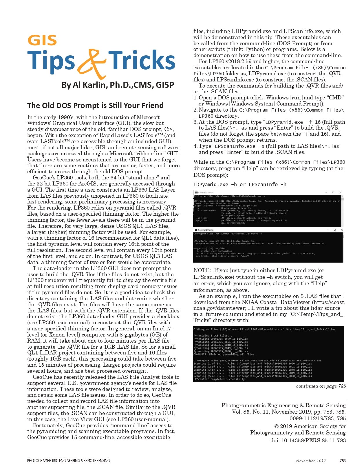
The Grids & Datums column has completed an exploration of
every country on the Earth. For those who did not get to enjoy this
world tour the first time, PE&RS is reprinting prior articles from
the column. This month’s article on The Republic of Suriname was
originally printed in 2002 but contains updates to their coordinate
system since then
I
nhabited by Carïb and Arawak tribes prior to European settlement, the coast of Suriname was sighted by
Columbus in 1489. Spain officially claimed the area in
1593, but Portuguese and Spanish explorers gave the area
little attention. Various attempts made to settle the area in
the 17th century failed until the first permanent settlement
was established in 1651 by the British Lord Willoughby of
Parham, governor of Barbados. Suriname became a Dutch
colony in 1667 according to the Treaty of Breda. The colony
did not flourish, however, and there were numerous uprisings by the imported slave population as well as conflicts
between the native tribes and the whites. Many of the
slaves fled to the interior and established the five major
Bush Negro tribes in existence today – the Djuka, Saramaccaner, Matuwari, Paramaccaner, and Quinti. Suriname
became independent on 25 November 1975. The backbone
of the Suriname economy is the export of alumina, produced
since 1941 after investments made by ALCOA. The majority
of aluminum (75%) used by the United States during WW II
originated in Suriname.
The area of Suriname is slightly larger than Georgia;
it borders Brazil (597 km), French Guiana (510 km), and
Guyana (600 km). The terrain is mostly rolling hills with
a narrow coastal plain with swamps. The lowest point is
within the coastal plain at –2 meters, the highest point is
Juliana Top at 1,230 meters. Most of Suriname is tropical
rain forest, and the majority of the 434,000 population lives
within 30 km of the northern Atlantic Ocean coast.
In April and May of 1886, observations were made by Captain Haan of the Steamer Surinam for the mean difference
in longitude between the stone stair landing of Paramaribo
and the flagstaff of Rickett Battery in Bridgetown, Barbados
by three time transfers. In May of 1886, similar observations
were made between Paramaribo and the upper signal of the
St. Marthe and St. Pierre Battery in Martinique. With computations obtained from the U.S. Navy as well as additional
Dutch measurements, the stone stair landing in Paramaribo
was finally determined to have an astronomical longitude of
Λo = 55° 29′ 02.0″ West of Greenwich.
In Annals Hydrographique, the French remarked that
in 1880, Dutch Lieutenant de Vaisseau de Première Classe
Mulder (Full Naval Lieutenant), observed a similar longitude that differed by only approx. 6 arc seconds; a remarkable feat, because it was done with chronometers!
Topographic mapping began in 1947 when 1:40,000-scale
aerial photography was flown by KLM Aerocarto. The initial
control was based on the Paramaribo Datum of 1947 where,
according to J. B. Wekker, Φo = 5º 49′ 25.40″ North and Λo =
55° 09′ 09.20″ West of Greenwich. This datum was referenced to the Bessel 1841 ellipsoid, where a = 6,377,397.155
m and 1/f = 299.152828. For mapping, the Kaart van Suriname Rousilhe Stereographic Grid was used where the latitude of origin, φo = 4º 07′ N, the central meridian λo = 55°
41′ W, the scale factor at origin was unity, the False Easting
= 300 km, and the False Northing = 775 km. The map compilation was performed by Centraal Bureau Luchkartering
(CBL). The area north of 4° N was mapped at 1:40,000 scale,
and the entire country was mapped at 1:100,000 scale.
During the 1960s a new primary triangulation network
was based on HIRAN – SECOR – BC4 – PC-1000 – Doppler Transit observations in Suriname. (An aspect of these
geodetic systems is that I am so old, I have had some association with all of them except for the PC-1000!) The new
local system is known as the Zanderij Datum of 1962 where
Φo = 5º 26′ 53.45″ North± 0.10″, Λo = 55° 12′ 19.04″ East
of Greenwich ± 0.10″, and the reference azimuth from RM
No. 1 to Az. Mk. measured from south αo = 261° 59′ 18.89″.
According to John W. Hager, “ … the station name of
HIRAN 14 AMS 1962 and latitude and longitude values
(seconds only) of 53.25″ and 19.22″. This is a difference of
8.27 meters. The equipment in 1962 was quite bulky and I
think that this later value represented the HIRAN antenna
position and that the astro was located the 8.27 meters
away. Another reason for having the astro point and the
antenna some distance apart is that they would be making
the HIRAN measurements simultaneous with or before they
would complete the astro observations.” The ellipsoid of reference for the Zanderij Datum of 1962 is the International
1924 where a = 6,377,388 m and 1/f = 297. The projection
adopted for this datum is the Suriname Gauss-Krüger
Transverse Mercator Grid, where the Central Meridian
λo = 55° 41′ W, the False Northing = zero, and the False
Easting = 500 km. Two scale factors at origin have been
noticed with this grid: mo = 0.99975 and m o = 0.9999, the
latter observed on some 1:50,000-scale maps dated around 1978.
The most common scale factor for the Suriname TM
Grid is mo = 0.99975.
In 1996, the U.S. National Geodetic Survey observed a
number of positions with GPS receivers, one point being
“008 Astro ECC 19″ where φ = 5° 26′ 54.62257″ N and
λ = 55° 12′ 19.04″ W. Although this is a different point
than the old datum origin, the similarity of the coordinates
show how close the NAD83 Datum is to the old Zanderij
1962 Datum. Proof of the pudding is the three-parameter
shift values published by NIMA in TR8350.2, 03 January
2000 where from Zanderij to WGS84: ∆X = –265m ± 5m,
∆Y = +120m± 5m, and ∆Z = –358m ± 8m. The NIMA solution was based on five collocated points. Thanks for a lot of
help on Suriname go to John W. Hager and to Mark Nettles.
Update
A fascinating account of a boundary recovery survey
used in the Guyana-Suriname Maritime Boundary
Delimitation by David H. Gray of Ottawa Canada is
found at:
https://pdfs.semanticscholar.org/6bc4/
c38aa6bdbac5a7359a6714d90eb9e9193ae8.pdf
Photogrammetric Engineering & Remote Sensing
Vol. 85, No. 11, November 2019, pp. 784–785.
0099-1112/19/784–785
© 2019 American Society for
Photogrammetry and Remote Sensing
doi: 10.14358/PERS.85.11.784